

New Delhi, May 17:
Very severe cyclonic storm, Tauktae (pronounced as Tau’Te), is likely to intensify further and cross the Gujarat coast between Porbandar and Mahuva on May 18 early morning between 2.30am and 5.30am with a speed of 155 to 165 kmph gusting to 185 kmph, with extensive damage expected in the affected areas, according to India Meteorological Department (IMD).

Large-scale damage is expected over Porbandar, Amreli Junagarh, Gir Somnath, Botad, Bhavnagar and coastal areas of Ahmedabad.
There is likely to be total destruction of thatched houses and extensive damage to kutcha houses; some damage to pucca houses; potential threat from flying objects; bending or uprooting of power and communication poles; major damage to roads; flooding of escape routes; minor disruption of railways; overhead power lines and signalling systems; widespread damage to salt pans and standing crops; blowing down of bushy trees; small boats, country crafts may get detached from moorings; visibility may be severely affected.
Some damage is also expected over Devbhoomi Dwarka, Kutch, Jamnagar, Rajkot, Morbi, Valsad, Surat, Vadodara, Bharuch, Navsari and Anand districts.
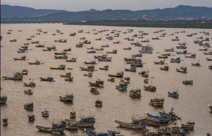
IMD has recommended evacuation of people from vulnerable areas, total suspension of fishing operations, judicious regulation of rail and road traffic, people in affected areas to remain indoors, movement in motor boats and small ships could be unsafe.
“Tauktae will intensify further while on its track and cross the Gujarat coast with a speed of 155 to 165 kmph gusting to 185 kmph. We are not expecting it to become a super cyclone but it is a big and intense system,” said Sunitha Devi, in charge of cyclones at IMD.
During the next 12 hours, Tauktae will continue to intensify drawing energy from the ocean. It is very likely to move north northwest wards and reach Gujarat coast by Monday evening and cross the coast very early in the morning on Tuesday. The system is being monitored by Doppler weather RADAR Goa.
Tauktae intensified very rapidly from a depression to a cyclone on Friday. There was rapid intensification of the cyclone on Saturday also. “Tauktae intensified by 65 kmph during the past 24 hours fuelled by heat and energy from the ocean,” said Roxy Mathew Koll, a climate scientist at the Indian Institute of Tropical Meteorology.
“With Cyclone Tauktae, this will be the fourth consecutive year of pre-monsoon cyclone over the Arabian Sea. This is also the third consecutive year when a cyclone has come very close to the west coast of India. Sea surface temperatures in Arabian Sea have increased rapidly during the past century and this has led to an increase in the frequency and intensity of cyclones in the Arabian Sea…global warming has presented us with new challenges such as rapid intensification of cyclones, which need to be closely monitored at higher resolution and accuracy using on-site platforms such as buoys and moorings. Improving the Indian Ocean Observing System (IndOOS) and incorporating the global warming signals in the weather models can help us tackle the challenges of intense cyclones in the future,” he added in a statement.
Sea condition over northeasy Arabian Sea will be very high to phenomenal (up to 14 metres high) and wind speeds (up to 64 knots) on Monday and Tuesday. Sea condition will be very rough to high ((9-14 metres wave height/38-63 wind speed in kts) along and off north Maharashtra coast on Monday morning. It is very likely to be very rough to high along and off south Gujarat coast from Monday morning and very high to phenomenal from Monday.
Tidal wave above astronomical tide (of about 3 m over Junagarh,1 to 2.5 m over Diu, Gir Somnath, Amreli, Bharuch, Bhavnagar, Ahmedabad, Anand, Surat and 0.5-1m over Devbhoomi Dwarka, Jamnagar, Porbandar, Kutch) are likely to inundate the coastal areas of Gujarat during the time of landfall.
Light to moderate rainfall is likely at most places with heavy to very heavy falls at a few places and extremely heavy rain (over 20 cm) at isolated places over south Konkan, north Konkan and Goa and adjoining Ghat areas on Sunday and Monday and heavy to very heavy falls at isolated places on Monday.
Over Gujarat, light to moderate rainfall is likely to commence over coastal districts of Saurashtra from Sunday afternoon, with heavy to very heavy falls at isolated places over Saurashtra, Kutch, Diu and southern most Gujarat region with extremely heavy falls at isolated places on Monday and heavy to very heavy falls at a few places over Saurashtra, Kutch, Diu and south Gujarat region with extremely heavy falls (≥ 20 cm) at isolated places on Tuesday. Extremely heavy rainfall is also likely over south Rajasthan on Tuesday.
Gale wind speed reaching 130–140 kmph gusting to 155 kmph is prevailing over eastcentral Arabian Sea. It is likely to increase over eastcentral Arabian Sea becoming 145-155 kmph gusting to 170 kmph from Sunday midnight. Squally wind speed reaching 40-50 kmph gusting to 60 kmph likely over northeast Arabian Sea and along and off south Gujarat, Daman and Diu coasts from Sunday and gradually increase becoming gale winds speed reaching 150-160 kmph gusting to 175 kmph over northeast Arabian Sea and along and off Gujarat coast (Porbandar, Junagarh, Gir Somnath, Amreli, Bhavnagar) and 100 -120 kmph gusting to 135 kmph over Bharuch, Anand, south Ahmedabad, Botad, Surendranagar, 90 -100 kmph gusting to 120 kmph over Devbhoomi Dwarka, Jamnagar, Rajkot, Morbi districts of Gujarat from early hours of Tuesday. Gale winds speed reaching 70-90 kmph gusting to 100 kmph likely to prevail along and off Dadra, Nagar Haveli, Daman, Valsad, Navsari, Surat, Kheda districts from Monday midnight till Tuesday morning.
