
By : Professor G. M. Bhat
Former Head, Department of Geology &

Principal Investigator of MoES funded Seismology and GPS Network in J&K
Earthquakes in the Himalaya dominantly result from the continental collision of the Indian and China plates, which are converging at a relative rate of 40-50 mm/yr. Northward under thrusting of the Indian Plate beneath the China Plate generates elastic strain energy in the rocks. When the rocks along the week zones reach their critical strength, a sudden movement takes place there and results in faulting along with sudden release of large elastic strain energy causing earthquakes. The surface expression of the Indian Plate boundary is marked by the foothills of the north-south trending Sulaiman Range in the west, the Indo-Burmese Arc in the east and the east-west trending Himalayan Frontal fold belt in the north of India.
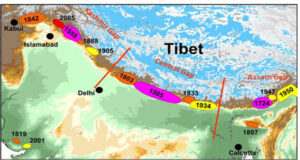
The India-China plate boundary is a diffuse boundary, which in the region north of India, lies within the limits of the Indus-Tsangpo Suture zone to the north and the Main Frontal Thrust to the south. The Indus-Tsangpo Suture Zone is located roughly 200 km north of the Himalaya Frontal fold belt and is defined by an exposed ophiolite belt (thrust sheet of ancient oceanic crust which has been obducted over the continental crust in the course of Himalayan orogeny) along its southern margin. The less than 200 km wide Himalaya Frontal fold belt includes numerous east-west trending, parallel thrusts along which most of the earthquakes occur and consequently makes this area one of the most seismically hazardous regions. The notable thrusts are Himalayan Front Thrust, Main Boundary Fault and Main Central Thrust. The Himalayan Frontal fold belt comprises of three seismic gaps i. e. the Kashmir Gap (KSG), the Central Gap (CSG) and the Assam Gap (ASG) (Figure 1). A seismic gap means a region in which elastic strain energy is accumulating over a long period of time (500 – 1000 years) but is not released intermittently making these areas vulnerable for major and great earthquakes.
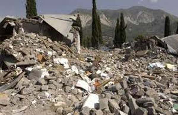
Examples of significant earthquakes, in this densely populated region, caused by reverse slip movement include the 1934 Bihar (M8.1), the 1905 Kangra (Mw 7.8) and the 2005 Kashmir (Mw 7.6) earthquakes. The latter two resulted in the highest death tolls for Himalaya earthquakes recorded to date, together killing over 100,000 people and leaving millions homeless in the KSG. The largest instrumentally recorded Himalaya earthquake occurred on 15th August 1950 in Assam, in the ASG. This right-lateral, strike-slip caused earthquake of M8.6 magnitude was widely felt over Asia, causing extensive damage in the epicentral region in Assam. Within the KSG during the recorded history three major earthquakes have occurred i. e. Kashmir earthquake in 1505 (M7.8), Kangra earthquake in 1905 (M7.8) and Muzaffarabad in 2005 (M7.8). In addition, one great earthquake of magnitude M8+ has occurred somewhere (probably within the Pir Panjal Range) in 1555. Roughly the return period of major or great earthquakes in the KSG is supposed to be about 500 years. However, this region has experienced strong (M6-6.9) and moderate (M5-5.9) earthquakes infrequently over the past few hundred years mostly concentrated to the southeastern (Chamba – Doda) and northwestern areas of the Kashmir Valley (Baramula District). Also minor (M3-3.9) to light (M4-4.9) earthquakes have been occurring in these areas. The IMD records show, the Chamba-Doda region has experienced 10 earthquakes of magnitude M5-5.5 over the past 40 years including earthquakes of magnitude M5.0 in 1975 & 1993; M5.1 in 1973; M5.2 ( 2 in 1980); M5.3 in 1974, (2 in 1975), 1976 & 1990. In addition, Kashmir Valley was struck by earthquakes of magnitudes of M6.5 in 1885 (Sopore), M5.5 and M5.0 in 1967 (Anantnag) and M5.3 in 1963 (Badgam). Jammu and Kashmir state falls within the seismic zones IV and V as per IS 1893 (part 1): 2002 and the Doda and Jammu region falls within seismic zone IV. However, a number of faults and thrusts traverse the region that makes it equally vulnerable as that of seismic zone V. Among these thrusts are the Kishtwar and Riasi thrusts which have produced moderate earthquakes in the recent past.
A series of earthquakes hit the erstwhile Doda district from 30th April 2013 with an earthquake of magnitude M4.6 with epicenter 16 km east of Doda (33.137°N, 75.747°E focal depth: 10.0km) at 09:41:52 UTC. This was followed by M5.8 earthquake (later revised to M5.4 by United States Geological Survey -USGS) on 1st May 2013 at 06:57:12 UTC with epicenter at N 33.10o and 74.84o, focal depth at 9.8 km. This was followed by 128 minor to light aftershocks (11 aftershocks were recorded on May 1st itself) (including nine aftershocks of M3.5 to 4.6) till 28th May 2013. This moderate earthquake of M5.4 magnitude with its epicenter in Jangalwar area near Bhadarwah caused huge damages to building structures and created panic in the erstwhile Doda District. Over the past one hundred years in general and for the last few decades in particular the area has witnessed a number of minor and moderate earthquakes. Moderate earthquakes are generally followed by aftershocks over a period of 3 to 4 weeks and ultimately they die down. Release of elastic strain energy from the rocks through moderate earthquakes reduces the chances of occurrence of major and great earthquakes.
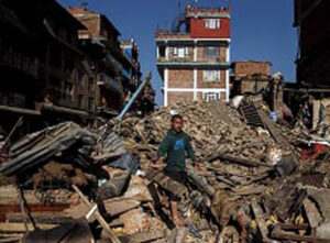
The ‘Riasi Thrust’ continues from the Barakh-Triyath area in northwest of Riasi and follows the Riasi Town and continues through Katra Town and beyond for ~60km. Continuity of this thrust (Balakot-Bag Fault) was responsible for the 8 October 2005 Muzaffarabad earthquake of magnitude M7.8 that killed nearly 86,000 people. The research teams from different universities and institutions (Indian and overseas) carried out scientific studies in the Riasi area in the recent past. One of the teams from the Oregon State University has modeled the seismic susceptibility of the Riasi area and has published their work in the Geological Society of America Bulletin in 2016.
Unfortunately, certain sections of the media have been carrying sensational news quoting different scientists from India and overseas about the occurrence of a major earthquake in the region which has leads to chaos and confusion among the people. In one such case, the Oregon University geoscientists were quoted as saying “Riasi would be the future epicenter of a major earthquake” that spread panic among the people and the state authorities. The local dailies and news channels projected the work by Oregon team in a way that has portrayed Riasi area as an earthquake flashpoint. While contacted by Naveen Hakhoo (Assistant Professor at the University of Jammu), Gavillot (the lead author of the paper) said “Just to clarify, our research does not make any sort of earthquake prediction, as the news has led the public to believe. Our research and results makes implications of the expected earthquake size based on the large scale geometry of the Riasi fault”. However, he is of firm belief that their assumption is based on the modelling of the ‘Riasi Thrust’ that has not broken in the recent past and may well break in the coming future. When will the ‘Riasi Thrust’ break “nobody can predict”.
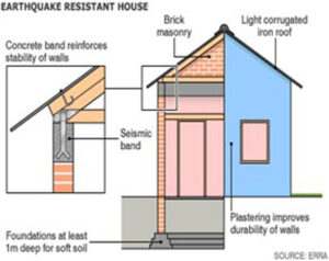
It is universally admitted fact that at the present state of knowledge about seismicity, it is not possible to predict future earthquakes in any part of the world. Scientifically there is no reason to claim that an earthquake of magnitude 8+ or 9 is going to hit the area in the near future. Therefore, people should not heed to rumors and there is no need to get panicky. However, we should bear in mind that Jammu and Kashmir falls within the seismic zones 4 and 5 (high risk zones) and should build earthquake resistant building structures (Fig. 2), construct the traditional building structures (Daggi Dewari and Taq system), etc. Analyze soil type before construction. Follow building codes for all sorts of structures. It is buildings that kill and not the earthquakes. Learn (DOS and DON’TS) during an event of earthquake and must know how to live in harmony with the disasters. For that we must gain knowledge about mitigation measures and become first responders in case of any future eventuality in the region.
